|
|
Home/ServicesAbout UsDrainage Tips For HomeownersWhat is Expansive Soil? Map of Expansive soils in Metropolitan PhoenixDrainage System ComponetsRain GuttersFoundation RepairFAQ Answer PagePost tension slab videoTestimonialsLandscape Drainage Solutions Service AreaRequest ConsultationContact UsHave A Comment or Question?BlogJob Openings
|

Soil Properties: Shrink/Swell PotentialA soil survey contains
maps Shrink/swell
potential is the 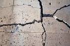
If a consumer purchases a home from resale inventory, the Buyer should always ask the Seller for a copy of the "Commissioners Public Report" for that subdivision. If the Buyer is purchasing a new build home, then the Builder is obligated to provide a copy of the "Commissioner’s Public Report" to the Buyer prior to the Buyer signing any contracts. In any case… no site sales associate, working for the Builder nor any real estate agent should ever issue a verbal warranty or claim as to the cause or nature or origin of these physical conditions, whether visible or hidden or whether disclosed or undisclosed. It is the responsibility of a prospective homeowner to satisfy his or her concerns by securing an independent assessment of the home/building and the structural integrity of that home/building. A licensed, bonded and insured (PE) Professional Engineer or (PEF) Professional Engineering Firm should tender such assessments, in writing to the party or parties raising such concerns.¨
|
